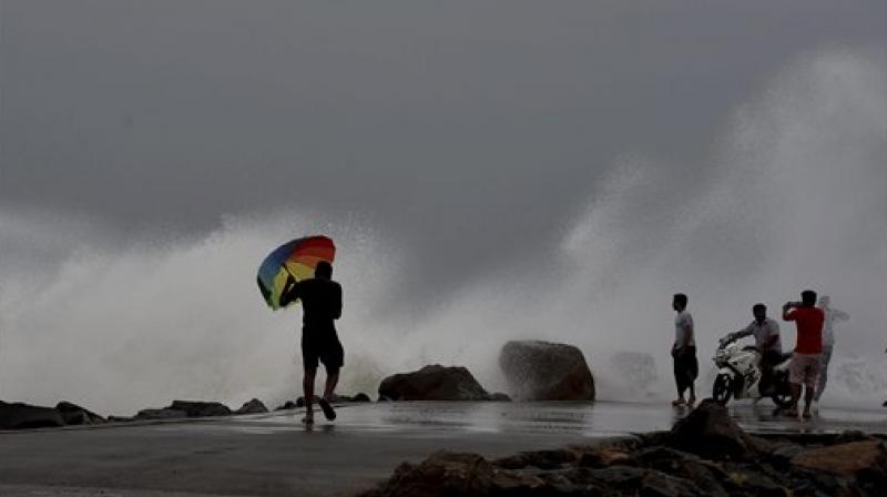
Cyclone Vardah makes landfall near Chennai, 2 killed in heavy rains
Traffic came to a grinding halt in most areas due to heavy rain, with uprooted trees and electric poles blocking roads.

Chennai: Two persons were killed as heavy rains accompanied by high velocity winds on Monday pounded the city and coastal districts of north Tamil Nadu due to severe cyclonic storm "Vardah" which began making landfall near Chennai, uprooting hundreds of trees, disrupting land and air transport and throwing normal life out of gear.
The wind speed had considerably reduced when the cyclone made landfall. The Navy said that while the leading edge of the storm was inland, the trailing edge would soon hit.
RK Pachnanda, DG of NDRF said that the location of the landfall was Pulicat in Tamil Nadu.
The National Disaster Management Authority (NDMA) said that the entire landfall process will be completed during the next 1-2 hours but conditions would remain rough even thereafter.
"The landfall process of cyclone Vardah has begun," the India Meteorological Department (IMD) earlier said.
According to M Mohapatra, Additional Director General (Services) of IMD, the "eye" of the Cyclone is 20 kms off Chennai.
"The wind speed near Chennai 90-100 kmph. Heavy rains and storm surge is expected. Landfall process has commenced at 2 PM. The cyclone will cross between 2-5 PM," Mohapatra said.
Heavy rains are expected to continue for the next 8 to 12 hours, said ANI.
Power supply was suspended in many parts of these regions as a precautionary measure.
Flight operations at the airport in Chennai have been suspended till 5 pm.
Long distance buses have been stalled and traffic came to a grinding halt in most areas with uprooted trees and electric poles blocking the roads.
All suburban train services have also been suspended.
Southern Railway announced cancellation of all 17 trains originating from Chennai central, as well as Egmore.
State Principal Secretary (Revenue Administration) K Satyagopal said "human loss is two", without elaborating.
In a statement, he said 260 trees and 37 electric poles had fallen and 190 trees removed. As many 224 roads were blocked and 24 huts damaged.
Andhra Pradesh Chief Minister N Chandrababu Naidu directed the Nellore district administration to evacuate people in about 255 low-lying areas to safer places even as the district started receiving rainfall since morning.
Food and other essential commodities have been kept ready in adequate quantities, said Naidu. He also added that fishermen should not venture out to sea for the next 36 hours.
The Tamil Nadu government for its part has advised people not to leave their homes until 4 pm.
7357 people are evacuated to 54 relief centres safely so far in Tamil Nadu. Over 9,400 people have also been evacuated from along the Bay of Bengal coast in SPS Nellore district of Andhra Pradesh.
10 diving teams have embarked on ships Shivalik and Kadmat, the Navy said.
Furthermore, 22 diving teams have been kept on standby at Visakhapatnam for immediate deployment.
Eight fishermen belonging to Tamil Nadu were rescued from the sea near the Sriharikota High Altitude Range while search was on for ten more persons feared trapped at sea.
"The police and CISF personnel are on the job and all the ten fishermen are safe. But they are somehow reluctant to come to the shore. We will soon bring them out," Nellore Superintendent of Police Vishal Gunni told PTI over phone.
"We have already moved over 9,400 persons in seven vulnerable mandals to safety. All necessary measures have been taken to ensure safety of people," Municipal Administration Minister P Narayana said.
In Sullurpeta mandal in Nellore district, 30 persons were shifted to a relief camp this morning.
The South Central Railway has cancelled some passenger trains between Sullurpeta and Chennai in view of the cyclone.
The Vijayawada-Chennai-Vijayawada Pinakini Express has been diverted via Renigunta and Arrakkonam. Some other Express trains on the Chennai route have also been diverted via Arrakkonam.
Meanwhile, all operations at Chennai airport have been suspended till 6 pm.
The earlier forecast made by the IMD was that it would weaken into a cyclonic storm, thereby reducing its intensity considerably.
At 9:30 am, the cyclone was lay centered around 105 kms east-northeast of Chennai. By the time it makes a landfall, its wind speed is expected to be 100-110 kmph with winds gusting up to 120 kmph.
The wind speed during a very severe cyclonic storm is 120 to 130 kmph. In a severe cyclonic storm the wind speed is somewhere between 110 to 80 kmph.
One of the major reasons for destruction in any cyclone is the wind velocity, apart from heavy to heavy rains and flooding.
Rainfall at most places with isolated heavy to very heavy falls over south coastal Andhra Pradesh, north coastal Tamil Nadu and Puducherry is very likely during the next 36 hours.
The rainfall intensity will increase gradually becoming heavy to very heavy rainfall (7-19 cm) at a few places and isolated extremely heavy rainfall (20 cm) over Chennai, Thiruvallur and Kanchipuram districts of Tamil Nadu and Nellore and Prakasam districts of Andhra Pradesh on December 12, the IMD said.

